It would have to involve a global positioning system, he says. Then thered be some kind of computer system, whether its a small thing, like the size of a PDA [personal digital assistant], or a full-blown laptop thats totally bomb-proof . And a digital camera to take pictures, which can then be associated with the data thats collected at that location.
Kemp may find that the biggest challenge he faces isnt getting his device built, but getting it used. According to Glenn Brooks, manager of a new geographic information data center at the UW, relief groups tend to be technology-averse organizations, for many reasonscost, technophobia, inability to run a computer in the desert. Its a sad irony, he says, that the one discipline where GIS could be most effective is the one where its least received.
But, he adds, I do see that changing.
Brooks is seated in what was once the living room of a creaky, tan 1920s bungalow on N.E. 12th Ave., just across from Condon Hall. The property is owned by the UW and administered by the Evans School, and for the past year has been the headquarters of a low-budget, high-tech data lab. Mercy Corps, a humanitarian nonprofit based in Seattle, donated eight computers and a one-terabyte file server, all equipped for GIS and remote-sensing work, and Brooks bought office furniture from Boeing surplus.
These are three-dollar chairs, he says. Everything in the building we bought for a hundred dollars.
Its hard to imagine anything of global significance happening in such a space. But the lab and its resident, all-volunteer organization, the Pacific Northwest GIS Response Team, were major players in the tsunami recovery effort, and are now up to their elbows in the Katrina cleanup.
Brooks, a soft-spoken man of about 60, has a longstanding interest in making disaster relief more efficient. He grew up in Alaska, and got his first taste of recovery work in 1964, rebuilding bridges and rail lines after the Great Earthquake and the tsunami waves it spawned. Later, he served as chief of police for the University of Alaska, where a good portion of the job was disaster responseearthquakes, volcanoes, wind storms, he says. I used to do all this, what we now call GIS stuff, using butcher paper and marking pencils to track serial offenders. I sometimes think I was born 25 years too early. He earned his professional certificate in GIS from the UW Extension in 1999, and for the past several years has been trying to introduce the technology to the disaster response field.
Not long after the 2004 tsunami hit, Brooks checked in with a friend at the Pacific Disaster Center in Hawaii. The staff was overwhelmed by the scale of the tsunamis destruction and wanted help processing satellite images. Brooks, who at the time was doing GIS work for Mercy Corps, agreed to take on some of the centers load.
But he needed a facility. He contacted the UW in early January, and his request quickly came to the attention of Elaine Chang and Evans School Dean Sandra Archibald. They saw that it was not only a compelling cause, but one that dovetailed beautifully with the goals of the new Interdisciplinary Program in Humanitarian Relief. Brooks recalls having access to a temporary GIS facility in a matter of days, and being offered the bungalow just a few weeks later. He and a team of about 50 volunteers spent the next several months converting satellite images to PC format and sending them back to the disaster center, which then posted them on its Internet map server.
The purpose, Brooks says, was to use remote sensing to show the before-and-after picture. He produces an 11-by-14 sheet of paper with two views of coastal Banda Aceh, Indonesia. Theyre similar, but the one on the right looks as though it has been scrubbed with steel wool. This is the day of the tsunami, Brooks says. There happened to be a satellite in the area. So you can see the differences, in terms of coastal erosion. And all these scattered white splotches are actually the cement pads where houses used to stand.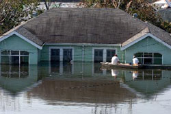
In the following months, about 20 UW student volunteers joined what had become the Pacific Northwest GIS Response Team. Brooks and the other volunteers trained them and put them to work. The student group was very instrumental in helping us do some follow-up mapping, he says, both of Sumatra and of Sri Lanka. We digitized about 2,000 house locations off of satellite imagery.
When Katrina came along, the team looked homeward. Brooks and his volunteers began compiling what they call the Katrina Disaster Atlasan electronic archive of interrelated maps that describe the storm and its myriad effects, from flooding to wind speed to economic impact and population displacement.
Go To: Page 1 | Page 2 | Page 3