
Using the Information Superhighway to Speed Up the Asphalt Freeway
Fuzzy logic is just one of the latest in a long string of innovations at the UW designed to make the going easier for freeway travelers, work that has helped put Seattle on the map as a center for cutting-edge traffic research, according to Mark Hallenbeck, director of the Washington State Transportation Center.
"The state Department of Transportation's (DOT) information systems are the best in the country," says Hallenbeck, whose center seeks to match state agencies' needs with researchers' expertise. "And the University has either directly or indirectly built the vast majority of that. The DOT folks have written the code for some of the Web sites that are physically running, but it was based on research by UW faculty—mostly engineering faculty—and it's really state-of-the-art work."
That work includes Web sites that display diagrams of Seattle's major freeways with color codes for current levels of traffic congestion, sites that show bus locations and predict arrival times for delayed vehicles, a cable television channel dedicated to real-time information on area traffic conditions, and analytical tools that give transportation engineers and policy makers hard data to consider when balancing transportation issues.
Dan Dailey is a good person to talk to about using the Information Superhighway to aid travelers on the old-fashioned asphalt freeway.
In fact, if you use "Web" and "traffic" in the same sentence at the UW, you'd likely be talking about Dailey, an electrical engineering research professor and director of the school's Intelligent Transportation Systems program who has been a key player in bringing Internet savvy to the traffic equation. His initial interests didn't lie in traffic, however—he worked with bubbles, specifically modeling the propagation of bubbles in nuclear reactors. The topics aren't as disparate as one might think.
"From an analytical or mathematical point of view, the propagation of traffic and the propagation of bubbles look kind of similar," Dailey says in his office in the new Electrical Engineering/Computer Science Building on campus, still dressed in cycling regalia from his morning commute. "You have different sizes and different speeds, they're passing one another, and you have a hard time getting a good look at the medium. You can only sense it occasionally and externally."
Dailey put his bubble expertise to use when he received funding from the DOT to understand traffic behavior as a random process. In 1990, he and his students created a computer program that shows how fast cars are going on the freeway. Other projects quickly followed. When King County Metro Transit installed a bus location system in the early '90s, Dailey was intrigued. He obtained permission to access the data—not an easy task because it was on a closed system designed by a defense contractor.
"We sent a student over with a 'sniffer,' " a computer program designed to covertly listen in and gather information from a system, "to eavesdrop on the network at their building downtown," Dailey recalls. "I don't think they thought we'd be able to do much with it."
Using data from the sniffer and digital maps, Dailey and his students figured out how to position the buses in real time.
"It took about a year, and we went back to them and showed them what we had," he says. "They said, 'Oh my God, we're not sure we want everyone to know that.' "
The application, called Busview, allows computer users to track their Metro bus in real time via a simplified map that runs on their computer screen. People found that interesting, according to Dailey, but what they really wanted to know was when their bus would arrive.
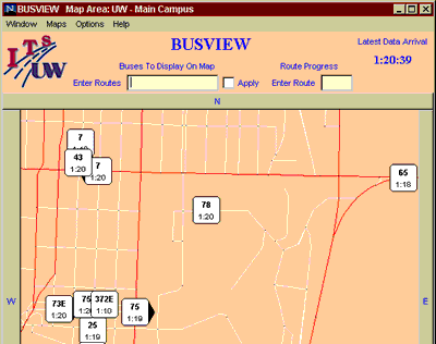
A portion of the Busview map displaying the current positions of buses around the northern half of the UW main campus.
"That's a lot harder," he says. "Predicting the future is a much more complicated proposition."
The resulting project, Transit Watch, placed computer monitors at selected transit centers to display arrival times for the buses. The screens are similar to airport monitors, a format already familiar to most people. The next step involved putting the information where people really want it, according to Dailey: "At their desk."
MyBus is a Java program that shows arrival times for buses at eight Seattle locations. That way, commuters can get travel information directly from their computer screens. While the programs won't make buses run on schedule, they do decrease anxiety and make commuting a more attractive option, Dailey maintains.
Another success has been Traffic TV, a program featuring real-time traffic information broadcast on the UW's experimental channel (76 on TCI in Seattle) twice a day during morning and evening commutes. Sort of a Weather Channel for traffic, the broadcast provides real-time traffic updates through a combination of maps and video shots of current commuting conditions.
- Return to June 2000 Table of Contents