UW Leads $18 Million Effort to Aid Transportation Alternatives
Underlying all those projects is a central system, designed by Dailey, that gathers and processes information gleaned directly from more than 3,000 sensors embedded in area freeways. The Intelligent Transportation Systems Information Backbone then makes that data available in a useable format via the Internet. This makes Seattle unique, according to Hallenbeck, and will be a critical factor in fueling the coming wave of portable traffic help devices.
"Wireless Web devices are one of the hottest things in the world right now," Hallenbeck says. "They're really neat, but they're only neat if you can actually get something useful out of them. Wouldn't you like to know how to get to work, and how to get home, and where your bus is? To do that, you need two things: a little wireless device that communicates and the information that you want to communicate to it."
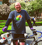
Dan Dailey, the director of the UW"s Intelligent Transportation Systems Program, beats traffic by commuting to work on his bike every day.
The ITS Backbone provides that information in an easily accessible format, allowing broad participation in the development of new traffic technology, says Dailey. It's also one factor—along with heavy traffic and a governmental push for alternate transportation research—that makes Seattle ground zero for cutting edge-traffic research.
"Seattle is a great place to examine these sorts of issues," says Dailey. In fact, Seattle was one of four cities selected as a demonstration site for a multi-million dollar federal pilot project to explore innovative transportation alternatives. The local version of the project is an $18 million undertaking known as Smart Trek. "Nationally, we're seen as a good testing ground because of those things that converge here."
Dailey's current work includes an effort to use cameras to gather information for traffic modeling. If successful, the method would provide a way of gathering traffic data in communities that lack Seattle's extensive network of highway sensors. It's a fantastically complex proposition because the cameras can be manipulated by operators, changing the view.
"But that's what makes it interesting," Dailey says. "That's what good science is about."
Hallenbeck also gathers and processes traffic information. He describes his work as similar to Dailey's but from an opposite approach and for a different audience.
"He's the real-time person, interested in getting information to people about what's happening now," Hallenbeck says. "I'm interested in the past. I'm the forensics guy. The information we provide is something policy makers can use."
- Return to June 2000 Table of Contents