Part Five: The Greatest Danger: The Seattle Fault
Of primary importance, particularly in light of the Nisqually quake, the maps will update recent discoveries and help planners better prepare for future earthquakes. The Waldron map does not indicate where the Seattle Fault lies, for the simple reason that no one knew the fault existed until the early 1990s. Geologists now have evidence that the northern edge of the fault zone basically runs along I-90 from Issaquah to Safeco Field, continues west through Alki Point, Restoration Point on Bainbridge, and Bremerton before terminating at Hood Canal. This 45-mile long, 2.5- to 4-mile-wide, east-west series of cracks has the greatest potential for significant earthquake damage in Seattle.
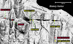
LIDAR iamge of Seattle Fault zone on Bainbridge Island. Identified are trench sites investigated by US Geological Survey in 1998 and 1999. Image courtesy USGS.
Unlike the Feb. 28 earthquake, which occurred 30 miles underground, movement on the Seattle Fault would occur within 10 miles of the surface and has the potential to rupture the ground. This happened most recently about 1,100 years ago, when the fault, in one dramatic movement, propelled rock up to 20 feet out of Puget Sound, triggering rock avalanches in the Olympics, underwater landslides in Lake Washington, and a tsunami that inundated West Point in Magnolia.
If a similar magnitude earthquake hit Seattle today, the city would be in shambles. We could expect damage similar to what happened in Kobe, Japan, in 1995. Port facilities, most of which are on fill, could be lost. Bridges and highways could collapse, and the shaking could trigger landslides larger than any produced merely by oversaturated soils. In addition, natural gas, sewer and liquid fuel pipelines, as well as major water supply lines, all of which suffered little or no damage in the 2001 earthquake, cross the Seattle Fault and could rupture if the ground moves 20 feet.
Their research, however, will not help predict earthquakes. "There is no scientifically reliable way of predicting the precise timing or intensity of an earthquake," according to Ruth Ludwin, a research scientist in the UW's Department of Earth and Space Sciences. For example, geologists know that the Seattle Fault last moved 1,100 years ago, and have some evidence possibly indicating two or three additional movements in the last 7,000 years, but that offers no more precision than sometime in the next several thousand years. For all anyone knows, the Seattle Fault could move tomorrow.
One of Troost and Booth's principal Seattle Fault-related activities is locating traces of the fault, such as folded or displaced layers. As chance would have it, a traffic jam led to the discovery of one of these features. In December 1998, Brian Sherrod, a USGS geologist affiliated with the UW, was sitting in traffic when he noticed a set of folded and faulted beds under southbound I-5, just south of downtown. Unable to look then, Sherrod returned to the spot with Troost and Booth. They were amazed to discover a 200-foot-long section of rock that appeared to have been squeezed from either end by massive bulldozers. Although some debate exists, the three believe that movement in the Seattle Fault zone deformed the 70,000-year-old lake bed deposits.

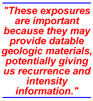
"These exposures are important because they may provide datable geologic materials, potentially giving us recurrence and intensity information," says Troost. "The more we look, the more we find. As additional sites of surface rupture appear, we will be able to provide planners with information to better predict how these materials will behave during earthquakes, how they transmit water, withstand loads, withstand steep slopes and affect natural resources."
"Having applied science like this is essential. The data will help determine where to focus investigations, both before and after events, and allow us to maintain a high level of planning," says Jim Mullen, director of Seattle's Emergency Management Program. "The Seattle Geology Mapping Project is what we've been waiting for. It is what will guide us. It will help us save lives."
© 2001 David B. Williams. David B. Williams is a free-lance writer. He is presently at work on a book on the natural history of the Seattle area.
Go To: Page 1 | Page 2 | Page 3 | Page 4 | Page 5
- Sidebar: The Quake on Montlake
- Return to June 2001 Table of Contents