1997
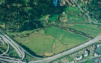
This 1997 aerial view shows the Richard Truly Farm in Bothell that would become home to UW Bothell and Cascadia Community College. The cow pasture at the bottom would be turned into wetlands.
The fact that the wetlands are so healthy right now and have attracted so much interest is a testament to the reclamation project that started in 1998, four years after the state's Higher Education Coordinating Board selected the land - known as the Truly Farm/Stringtown site - as the home for a new campus of the University of Washington and a new community college.
The site consisted of 127 acres of drained pastureland that was a longtime beef cattle and dairy farm run by Boeing engineer and part-time rancher Richard Truly.
Reclaiming the area has not been easy. "The land was highly degraded," says Lee. "The plant community was in bad shape by an invasion of Eurasian weeds. The habitat for the fish in the stream was in bad shape. Restoring it to its natural state has been a major undertaking."
The choice puzzled observers who wondered why the state would pick a parcel that had a wetlands area that could never be developed. Developers who had thoughts of turning the area into a shopping center walked away because of the prohibitive cost of dealing with the wetlands. And one prominent member of the University of Washington Board of Regents was particularly galled, going so far as to call the land "half swamp."
Located at the southernmost tip of the 12 1/2-mile-long North Creek Channel, the wetlands serve a watershed of nearly 30 square miles in Snohomish County. Starting near Everett, North Creek drains into Lake Sammamish, which in turn empties into Lake Washington.
The degradation of the wetlands' original lush state began in the late 1860s following the arrival of white settlers. England native George Rutter Wilson, who staked a claim there in 1862, logged the timber from his homestead to finance its early development as a farm. In 1880, a log flume was constructed, using water from North Creek, the small river that crossed his property. In constructing the log flume - designed to carry the logs to saw mills along the shore of Lake Washington - North Creek was straightened and ditched, helping drain his low-lying property. He removed tree stumps, graded the land and built a house.
In 1916, he sold his property to Benjamin Ewing Boone, a businessman who wanted to turn it into a duck-hunting club. That same year, the character of the land changed when the opening of the Chittenden Locks in Ballard and the completion of the Montlake Cut resulted in the lowering of Lake Sammamish and Lake Washington by up to 11 feet. That caused the land to become a pastureland, so Boone converted it into a cattle ranch.
The land remained a ranch until the early 1990s, when Truly decided to sell.
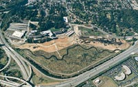
Once the state settled on the site, it faced some major challenges. The buildings for UW Bothell and Cascadia Community College are built on six acres of sloping wetlands themselves. (In order to mitigate that impact under the Clean Water Act, the lowland restoration was undertaken.)
"Our task was to figure out what to do with it," explains Lee. "It took 80 years for the area to be changed from a forest into a pasture. We would just be setting things in motion. You can't change it back in one or two years. It will take a long time."
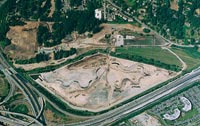
Bulldozers and earthmovers graded the site, removing invasive weeds in the process and then cutting new meandering channels. Then, ecologists added floodplain features such as small hills and ditches.
Go To: Page 1 | Page 2 | Page 3