
Of these three intensive programs, short-term predictions based on El Niño has become the star performer, with increasingly accurate predictions now widely available. Even the U.S. government is now issuing a thick monthly manual of predictions for the coming year.
"I get invited to talk to the Oil Heat Institute every year and they want the latest El Niño forecast because they need to know how much oil to stock up," says Atmospheric Sciences Professor Clifford Mass. Every industry affected by climate, from clothing manufacture to water management, wants the predictions, he says. As Sarachik points out, "Predictions help stabilize markets."
El Niño has been known since the last century when Peruvian fishermen noticed that in many years, usually around Christmas, unusually warm coastal waters brought a sudden, months-long change in the climate. They called the phenomenon "the Christ child," or El Niño in Spanish.
Gradually the term came to refer to the episodic appearance of warm surface waters into the normally cold waters of the central and equatorial Pacific. In time, another phenomenon involving a global redistribution of barometric pressure, the Southern Oscillation, was shown to fluctuate in step with the comings and goings of El Niño. Acknowledging that the ocean and atmosphere are linked by the mutual transfer of heat, moisture and motion, scientists now call the entire climatic phenomenon ENSO (an acronym for El Niño and Southern Oscillation).
And although ENSO occurs in a narrow equatorial belt about 500 miles wide, its global effect is powerful, with a typically warm (El Niño ) climate lasting from a few seasons to several years. The most devastating conspiracy of ocean and atmosphere this century occurred between 1982 and 1983, bringing drought to Indonesia, Africa and Australia and severe flooding in South America, disasters that cost thousands of lives and resulted in $13 billion in damage worldwide. In the U.S. there were storms and mud slides in California, flooding in the Gulf states, and a sharp reduction in the salmon catch in the Pacific Northwest. Since then there has been ENSO warming in 1986-1988 and in 1992. Wallace notes that a sudden increase in ocean temperatures this summer signals the onset of what looks to be a very strong return of El Niño this year.
The 1982 El Niño caught scientists by surprise. But since then the U.S.
government has supported a continuing international effort to study the
phenomenon. One of the most visible signs is a string of 70 research buoys
stretching across the Pacific, each tethered by a nylon line over a mile long,
measuring everything from ocean temperatures and currents to surface winds.
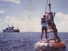
The buoys are part of an observing system sending a daily stream of data via satellite to the prediction centers around the globe. The buoys were developed and are maintained by National Oceanic and Atmospheric Administration scientists in Seattle, and among the users of the data is a federally supported research center at the UW, headed by Sarachik.
Stroking his black Labrador Margaret, a constant presence in his office, he says, "We now understand that El Niño alters the mean climate of the Earth. Without El Niño it would be a different Earth, a little cooler in the East Pacific with a different distribution of temperature between the north and the south."
But he also speaks of the continuing complexities of understanding El Niño. Nine years ago, UW Professor David Battisti first advanced the currently accepted theory that ENSO arises through a coupling of an unstable ocean and atmosphere, and that the events recur an average of every four years. "Why four years?" Sarachik asks. "There is nothing intrinsic in the climate system that says it should be four. We might expect a year, because the sun moves back and forth over that period."
There are other complications. Years in which tropical sea surface temperatures are below normal--the flip-side of El Niño--tend to have colder winters brought by what has been dubbed La Niña (the young woman). Professor Mass has studied the effect of La Niña years on snowfall at SeaTac Airport, and has found that the winters averaged 16.9 inches of snow. During El Niño winters the average was only five inches. It isn't that there is more precipitation during La Niña years, he says, it's just that the freezing level is much lower in the atmosphere, resulting in more snow.
Last winter was such a La Niña period, resulting in the Christmas week winter storms that slammed into the Northwest. Seattle's bus operator, Metro, was especially hard hit, says Sarachik. "There were no chains for the buses because it hadn't snowed for five years. If Metro had asked me I would have told them, buy chains this year. I couldn't have told them exactly when it was going to snow, but I could have said the probability had shifted toward snow. We had that information."
The sudden year-to-year differences between ENSO and La Niña can also spell troubles for water managers. Because the El Niño period produces warm storms, snow freezes only on the higher elevations, meaning a smaller snowpack and less spring runoff. In 1992 Seattle had an acute summer drought, with restrictions on water use. It was the result, says Mass, of water managers ignoring advice from El Niño experts to close their dams early and allow the water to rise in the reservoirs. Instead, the water levels were kept low, and the spring runoff couldn't fill the reservoirs.
Medium-Term Predictions: Ocean Monitoring is the
Key
Long-Term Predictions: The Threat of Global
Warming
Send a letter to the editor at columns@u.washington.edu.
![]()