The shaking began slowly and gently, as if a train were passing. As the seconds seemed to stretch longer and longer, however, the shaking became a rumbling with walls and windows swaying and rattling, followed by cracks creeping up walls, bricks cascading from above, and chimneys buckling. Then it ended, and a short-lived, eerie silence descended.
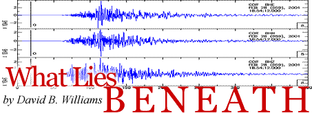
Few people who live around Puget Sound will ever forget where they were at 10:54 a.m. on Feb. 28, 2001, when the third major earthquake of the last 52 years rocked the region. Like the two previous quakes, the 2001 event occurred deep underground (30 miles) when the Juan de Fuca plate slid under the North America plate. The 6.8 magnitude earthquake released an energy wave equal to 4 billion pounds of TNT—nearly a million times more dynamite than it took to raze the Kingdome. Damages totaled more than a billion dollars, but fortunately no one died as a result of the tremor.

A Seattle retail shop shows massive earthquake damage. Photo by Kevin Galvin, FEMA News Photo.
University of Washington geologists Derek Booth and Kathy Troost were on campus when it hit. Both immediately knew what was happening and headed to the nearest doorway, but they did not stay long. As police closed bridges and viaducts, and as residents of Pioneer Square scrambled out of crumbled buildings, Derek and Kathy realized they were just beginning a great adventure.
The pair hopped into Troost's dark blue, convertible Miata and sped down to Seattle's SoDo area in search of damage. Specifically, the two wanted to locate areas of liquefaction, which occurs when an earthquake violently shakes sand and silt fill, forcing the sudden release of water within the sediment. This commonly causes structural failure during earthquakes, as the weakened soil turns into a tofu-like material and can no longer support great weight.
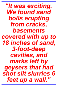
"It was exciting. We found sand boils erupting from cracks, basements covered with up to 18 inches of sand, 3-foot-deep cavities, and marks left by geysers that had shot silt slurries 6 feet up a wall," says Troost. Probably very few people in the city could then utter her following words: "The earthquake enhances and validates what we are working on. For that we are grateful."
Geologists are a funny lot. While many folks were trembling in fear during the Nisqually tremor, for Derek and Kathy the earthquake happened at a particularly opportune time.
Under the auspices of the United States Geological Survey (USGS), the University of Washington and the city of Seattle, Booth and Troost are producing a series of geologic maps that will paint an unprecedented picture of the geology of one of the most complicated cities in the country. The Seattle Mapping Project will be incorporated into the Federal Emergency Management Agency's "Project Impact," a program to help cities prepare their infrastructure and citizens for natural disasters. Seattle is one of only three localities, along with Memphis and Oakland, developing such detailed maps.
Go To: Page 1 | Page 2 | Page 3 | Page 4 | Page 5
- Sidebar: The Quake on Montlake
- Return to June 2001 Table of Contents